Construction projects can get really complicated, and even small mistakes can end up causing big delays. In fact, a study by KPMG found that around 70% of construction projects go over budget and miss their deadlines.
One major reason behind these setbacks, something that often gets ignored, is poor land surveying. If you don’t have a clear understanding of the land before starting, you’re more likely to run into unexpected problems that slow things down and cost more money.
In this article, we’ll break down why proper land surveys are such a crucial part of construction planning and how they can help avoid issues and keep your project on track.
Why Construction Planning Starts with a Land Survey
Construction projects rely on precision. Before a single machine is brought on-site, survey data lays the groundwork for every major decision. Without it, even a well-designed project can fall apart under real-world conditions.
Land surveys provide the measurements, boundaries, and physical details needed to align the plan with the actual land. They are not an optional extra, they are the first technical check that makes sure your project can legally and practically move forward. No matter the size of the build, this step ensures your design fits the physical space and complies with local regulations.
Land Surveys Define Legal Boundaries
Surveyors identify the exact perimeter of the property by using GPS equipment, total stations, and legal documentation like title deeds and past surveys. This confirms where your lot ends and where neighboring lots begin. Without this verification, construction could accidentally cross property lines, triggering legal challenges or forced modifications mid-project.
If you’re building near a fence, easement, or road, a boundary dispute is one of the most expensive problems to resolve after construction begins. Getting the legal edges of the property defined at the start removes that risk entirely.
Topographic Features
Most land is not perfectly flat, and ignoring this can lead to flawed foundation design, drainage issues, or structural instability. A land survey records the precise elevations, slopes, and terrain variations that influence how the site should be graded or excavated.
This data allows engineers to design structures that follow the land’s natural form or account for needed adjustments in the plan. For example, retaining walls, tiered foundations, and runoff channels can all be designed properly once topography is mapped.
Physical and Man-Made Features
Land surveys don’t just track boundaries and elevation, they also log features like trees, ditches, utility poles, and existing buildings. These details are necessary to plan around obstacles and reduce the need for costly removals or rework.
Overlooking a buried water line or a mature tree near a planned driveway can create setbacks that delay your schedule and increase your costs. Surveyors flag these details early so the team can adapt before construction begins.
Building Codes and Restrictions
Many construction projects fail to account for municipal rules until they’re too far along. Land surveys show zoning limits, setbacks, easements, and protected areas that may affect how close you can build to a road, stream, or other property.
This information helps architects and engineers modify plans to meet legal requirements before permit applications or inspections get denied. A project that fits the land and follows the rules from day one is far more likely to finish on time and without compliance issues.
Types of Surveys Used in Construction Projects
Every construction site comes with its own set of challenges. That’s why land surveys aren’t just a checkbox, they’re chosen and tailored based on the specific needs of the project. Each type of survey delivers different insights that shape how a build progresses.
In this section, we’ll look at two of the most commonly used surveys in construction and explain how they impact planning, permits, and execution.
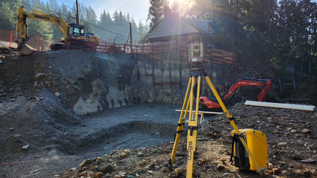
LiDAR Surveys
LiDAR surveying uses laser scanning technology to create highly detailed 3D models of the land surface. Mounted on drones, aircraft, or tripods, these sensors capture millions of elevation points, even through dense vegetation or rough terrain. This allows engineers to map the site with exceptional accuracy, much faster and more thoroughly than with traditional surveying alone.
Topographic Surveys
Topographic surveys capture the vertical details of a site, showing changes in elevation, slopes, depressions, and how water might move across the land. These surveys also record man-made features such as ditches, curbs, retaining walls, and utility covers.
This information is used by engineers to design foundations, retaining systems, and drainage plans that match the natural lay of the land. A site that appears flat to the eye may have subtle changes that affect grading or flood control. A topographic survey ensures you’re not designing blind, it gives your team the data needed to prevent erosion, water pooling, or uneven settlement.
How Land Surveys Prevent Costly Mistakes
Missing this early step often leads to big, avoidable problems.
Land surveys don’t just provide data, they prevent serious setbacks. Construction without surveying is like building furniture without measuring the wood: things don’t fit, and time is wasted fixing avoidable mistakes. These errors can snowball into delays, legal battles, and budget overruns.
Building in the Wrong Spot Creates Legal Trouble
If a structure is built over the property line, even by inches, it may need to be torn down or relocated. These errors are common when developers skip or rely on outdated surveys. Courts often side with documented land rights, not with good intentions.
Underground Utilities Can Be Accidentally Damaged
Some surveys include underground mapping, showing where gas lines, water pipes, and electrical conduits run. Damaging these lines not only halts construction but can also result in fines and dangerous accidents. Locating them early avoids all that.
Land Surveys and Zoning Compliance
Zoning laws tell you what can be built and where; it’s the survey that shows if your plan fits.
Even if you own the land, you can’t build whatever you want, wherever you want. Municipal zoning codes place strict limits on the use of land and space. Land surveys show how your project fits within these laws, before violations occur.

Setback Requirements
Zoning regulations often include “setbacks,” which are minimum distances a building must sit from roads, property lines, or water bodies. Land surveys help planners visualize these setbacks on the actual site and adjust their designs to meet requirements.
Secure Permits Faster
Building permits often require a current land survey before approval. Submitting clear, accurate survey data reduces back-and-forth with the permitting office and can speed up the green light to start construction. It shows the authorities that the plan is ready and compliant.
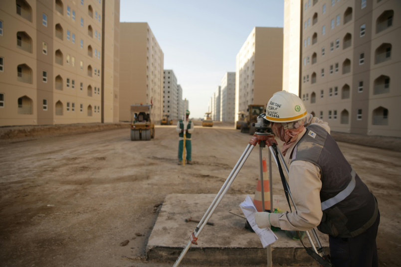
Land Surveys in Large-Scale Developments
As projects grow, so does the need for detailed, ongoing surveying.
In major developments, like housing subdivisions, commercial centers, or industrial zones, surveying doesn’t just happen once. It’s integrated throughout the entire process to track progress, adjust plans, and keep everything aligned from start to finish.
Initial Surveys Shape the Master Plan
Large-scale projects start with an extensive survey that defines everything: property boundaries, topography, access points, and environmental restrictions. These findings directly influence how lots are divided, where roads go, and what parts of the land are usable.
Progress Surveys Keep Construction on Track
As work begins, surveyors return to verify that foundations are placed correctly, elevations match design specs, and structures comply with the approved plan. These mid-project surveys catch problems early, when they’re still cheap to fix.
Final Word
If your project needs clear, accurate, and timely land data, you don’t have to figure it out alone. 360 Land Surveying provides professional surveying services across British Columbia, including advanced types of surveys for detailed terrain mapping. Our team helps you move forward with confidence before the first shovel hits the ground. Contact us now!