Picture this: you’re trying to plan a new neighborhood or improve an existing city area, but you’re stuck dealing with outdated maps and incomplete data. How can you make the right decisions when you don’t have the full picture?
This is where LiDAR comes in. LiDAR technology provides accurate, detailed information that makes urban planning and land development faster, easier, and smarter.
In this article, we’ll look at how LiDAR Services are changing the way cities are built and improved, helping create better spaces for people to live and work. Let’s explore how this powerful tool is shaping the future of urban development.
Understanding the Basics of LiDAR Services & Technology
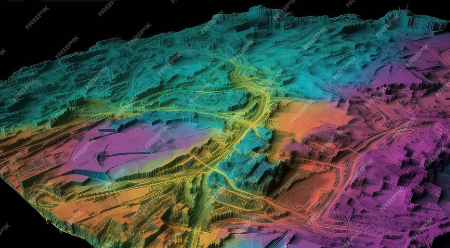
LiDAR, which stands for Light Detection and Ranging, is a remote sensing technology that uses laser light to measure distances and create detailed, three-dimensional images of the environment.
A LiDAR system is made up of four key components: a laser, a scanner, a GPS receiver, and an inertial measurement unit (IMU).
The system works by sending out laser pulses toward a target and measuring how long it takes for the reflected light to return to the sensor.
This process happens millions of times per second, resulting in a dense collection of data points, known as a point cloud, that shows the surface’s shape and features. This data is then processed to create detailed maps, elevation models, and other useful information.
There are three main types of LiDAR systems, each designed for specific uses and applications.
- Airborne LiDAR: This system is mounted on manned or unmanned aircraft and is best suited for covering large areas. It is commonly used for topographic mapping and environmental studies.
- Terrestrial LiDAR: Ground-based systems are used to collect high-resolution data, making them ideal for detailed surveys of smaller areas, such as construction sites.
- Mobile LiDAR: Mounted on vehicles, this system combines the benefits of both airborne and terrestrial LiDAR, providing a good balance between wide-area coverage and high accuracy.
How LiDAR Supports Land Development Projects?
LiDAR’s flexibility makes it a valuable tool for many types of land development projects. From big infrastructure projects to smaller residential developments, it helps with detailed preparation, leading to better and more successful project results:
Accurate Terrain Analysis
Accurate digital elevation models (DEMs) and contour maps are key for site analysis, earthwork calculations, and drainage design. LiDAR’s ability to capture detailed terrain features helps engineers and planners create and optimize site layouts more effectively.
3D Urban Models for Smarter Planning
Using LiDAR data, detailed 3D models of urban areas can be created. These models help planners analyze how land is being used, find new development opportunities, and assess the effects of proposed projects.
Monitoring and Maintaining Infrastructure
LiDAR’s high-resolution point clouds are used to check and monitor transportation infrastructure like roads, bridges, and tunnels. LiDAR data also helps assess how natural hazards affect these structures.
Assessing Ecosystems with LiDAR Data
LiDAR collects detailed information about vegetation, wetlands, and sensitive ecosystems, which is important for carrying out environmental impact assessments.
Reducing Flood Risks with LiDAR Insights
LiDAR-derived elevation data is used to create flood models, helping developers identify areas at risk and plan flood prevention strategies. Knowing how flooding could affect an area allows communities to create strong emergency response plans and invest in protective infrastructure.
These uses, along with others, give developers helpful insights early in a project. More data means better understanding, which leads to smarter planning, proactive decisions, and fewer problems that could slow down or stop a project.
Exploring the Benefits and Limitations of LiDAR
LiDAR technology has changed urban planning by providing high-quality data that helps planners make better decisions. Lets look at the benefits and challenges of using LiDAR in urban planning.
Saving Time and Money
One of the biggest benefits of using LiDAR in urban planning is the time and money it saves. Traditional surveying methods can take a lot of time and effort, but LiDAR can quickly and efficiently map large areas.
This speed helps lower labor and equipment costs, making LiDAR an affordable option for many planning projects.
Precision in Urban Planning

LiDAR provides very accurate and detailed spatial data, which is important for urban planners to make smart decisions. With accuracy usually within a few centimeters, LiDAR data is extremely useful for tasks like designing infrastructure, analyzing land use, and assessing flood risks.
Rich Datasets
LiDAR technology collects detailed information about various features like terrain, vegetation, buildings, and infrastructure. This complete dataset gives urban planners plenty of useful information to base their decisions on, helping to achieve better planning and development results.
All-In-One Approach to Data Collection
The high-quality data from LiDAR technology helps urban planners make better decisions, leading to more effective and sustainable urban development. By providing detailed information about current conditions and possible impacts, LiDAR allows planners to find the best solutions and reduce potential risks.
What’s Next for LiDAR in Urban Planning?
As LiDAR technology improves, its uses in urban planning are expected to increase and become more diverse. Some future trends to look out for include:
- Combining LiDAR with other geospatial tools, like satellite images and GIS, to create even more detailed datasets for urban planners.
- Improvements in artificial intelligence (AI) and machine learning are making it easier to analyze LiDAR data more effectively, leading to better decision-making and planning results.
- Smaller and more affordable LiDAR sensors are being developed, which can be mounted on drones or other platforms, making the technology available to more users and for more applications.
- The increasing use of LiDAR for real-time monitoring and analysis helps urban planners react quickly to changes in the urban environment and make proactive decisions based on accurate data.
LiDAR’s Lasting Impact on Urban Development
LiDAR has changed land development by offering incredible accuracy and detail. Its ability to gather precise data quickly has improved surveying and project planning. Simply put, LiDAR helps professionals make better decisions, improve project designs, and reduce risks at the very beginning of a project. Ready to get started? Reach us out to get started with accurate LiDAR Services.