Dense vegetation can be a serious obstacle in property surveying. Whether you’re planning a new development in a wooded area or assessing an overgrown lot, traditional methods like on-foot surveys or standard aerial imagery often fall short. That’s where Drone LiDAR steps in and changes everything.
In this blog, we’ll explore how Drone LiDAR works, how it interacts with vegetation, and whether it can truly “see through” trees, grass, and brush to deliver accurate survey data. We’ll also look at real-world limitations, practical setup tips, and when you may still need a human on the ground.
Why Vegetation is a Problem in Property Surveying
Surveying through vegetation isn’t just about inconvenience, it’s a data quality issue. Trees block views from the sky, shrubs obscure boundaries, and tall grass can throw off elevation readings. Manual surveys in these environments take longer, cost more, and often put field crews in contact with thorns, poison ivy, or even dangerous wildlife. Plus, traditional aerial imaging, like satellite or drone-based photogrammetry, can only capture what’s visible from above. When the ground is hidden by a thick canopy, elevation models become wildly inaccurate.
That’s why developers, utility companies, and land surveyors are turning to Drone LiDAR.
How Drone LiDAR Works
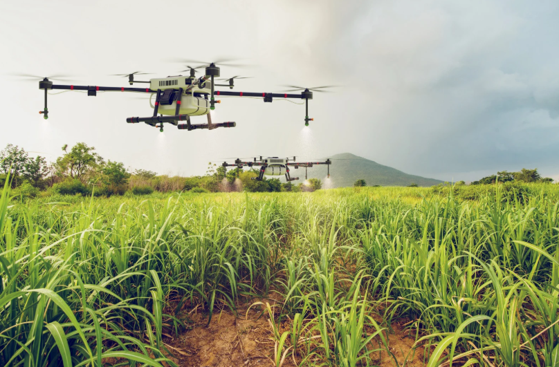
 LiDAR stands for “Light Detection and Ranging.” In a drone survey, a LiDAR-equipped drone emits rapid laser pulses toward the ground. Each laser bounces off a surface, whether it’s a leaf, a branch, or the bare earth, and returns to the sensor. The system measures the time it takes for the signal to return and uses that data to calculate distance.
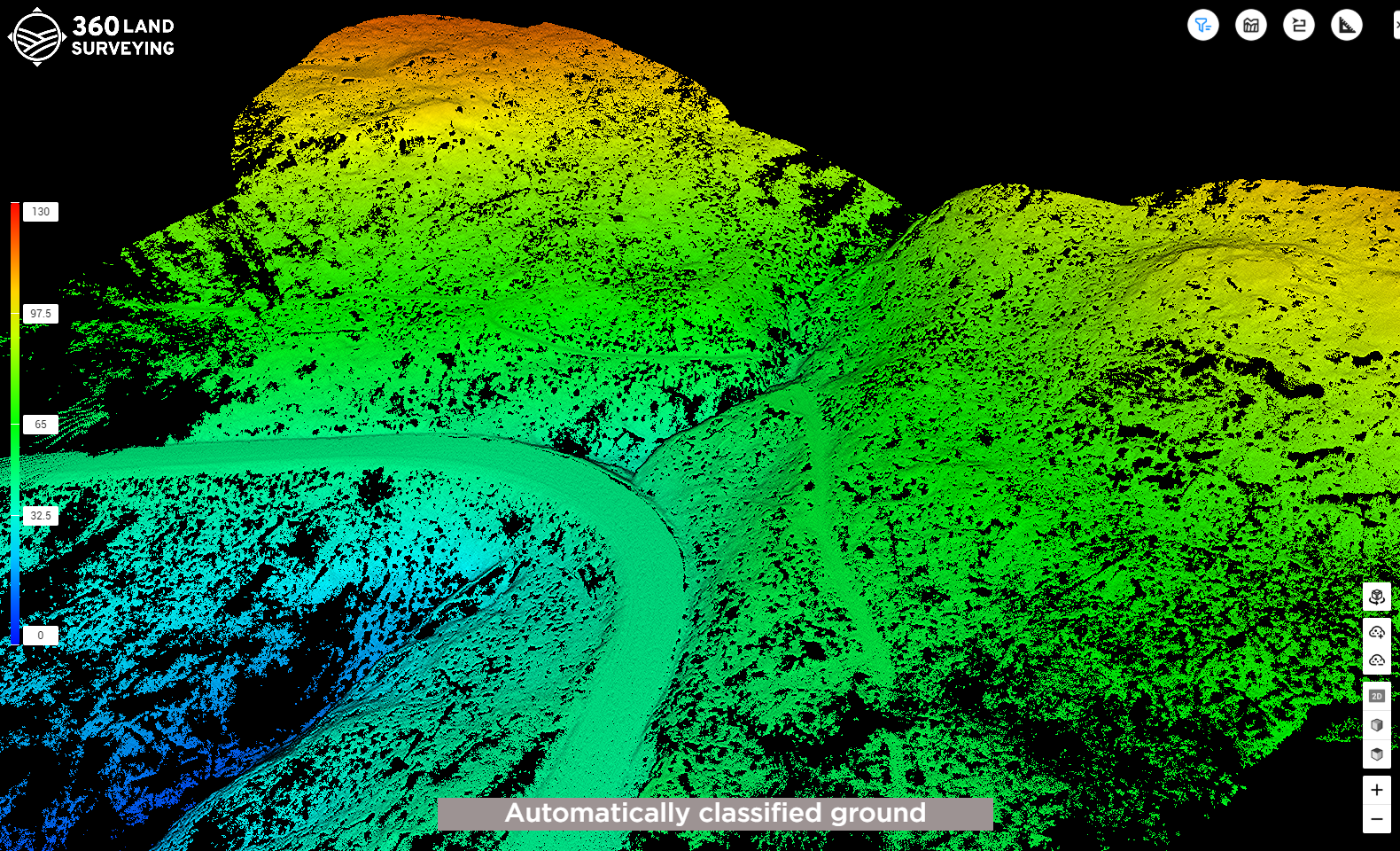
What makes this technology stand out is the rate of laser emissions. Some systems fire up to 1.4 million pulses per second. This generates what’s called a point cloud, a high-density map of millions of georeferenced points that collectively form a detailed 3D model of the landscape. Unlike standard cameras, LiDAR doesn’t rely on visible light and doesn’t need to “see” the ground, it just needs gaps to fire laser pulses through.
Can Drone LiDAR Really See Through Vegetation?
In short: yes, to a surprising extent.
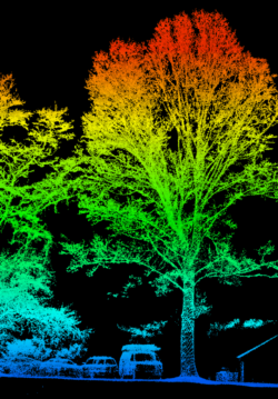
Drone LiDAR can penetrate foliage by sending laser pulses through tiny gaps in leaves and branches. As those pulses reach the ground and bounce back, the system collects multiple returns from different layers: the tree canopy, the understory, and the bare earth. The result is a layered model of the landscape that clearly distinguishes between vegetation and ground surface.
In forested terrain, LiDAR routinely captures ground elevations within a tenth of a foot of accuracy, far more precise than GPS-based walkovers. It excels in wooded environments where visibility is poor, and GPS signals can be weak due to canopy interference.
What About Tall Grass and Shrubs?
This is where things get more nuanced. LiDAR does a better job at penetrating tree canopies than it does tall, thick grass. That’s because trees have vertical gaps between leaves and branches, which allow laser pulses to sneak through. Grass, on the other hand, grows tightly together, forming a horizontal mat that reflects the laser at the top surface.
Still, in many open-field scenarios, Drone LiDAR can generate usable elevation data, even in tall grass. The accuracy just might drop slightly, especially in shadowed or densely packed zones. In these cases, targeted manual ground checks can be used to fill in data gaps and validate contours.
Comparing Drone LiDAR to Piloted Aerial LiDAR
According to a peer-reviewed study published in the Journal of Unmanned Vehicle Systems, UAV-LiDAR (drone-based systems) produced 2–3 times lower vertical errors than traditional piloted LiDAR aircraft in every vegetation type tested. This improved accuracy is due to:
- Lower scanning range
- Smaller laser footprint
- Higher point density
In practical terms, this means that drones for surveying can fly lower and slower than manned aircraft, offering more detailed and reliable data, especially in overgrown areas where precision is everything.
What Drone LiDAR Can’t Do
While Drone LiDAR excels in vegetation, it has some key limitations:
- Water: LiDAR can’t penetrate standing water. If a construction site includes ponds, creeks, or stormwater basins, the laser pulses will scatter and fail to detect the ground beneath. You’ll need to wait for the water to recede or pump it out before conducting a survey.
- Snow: Snow behaves similarly to water. Its crystalline structure scatters laser pulses and prevents accurate ground detection. In snow-covered landscapes, LiDAR can only capture the snow’s surface, not the terrain below.
- Poor Weather: Rain, fog, and dense cloud cover reduce the effectiveness of laser pulses. While some data can still be captured, the overall accuracy and point density will suffer. For best results, LiDAR services should be performed in clear weather.
Sensor and Altitude Matter
Not all LiDAR sensors are created equal. Entry-level sensors may struggle in dense brush or layered canopy, while advanced units, equipped with multi-return capability and high scan rates, can handle far more complex vegetation.
Similarly, altitude plays a role. Entry-level systems typically operate best between 150–200 feet. Higher-end sensors can maintain accuracy at greater heights, which is useful for covering large properties more efficiently.
Forest Mapping and Powerline Safety in Land and Property Surveying – Real-World Example
One notable case study involved forest mapping in Scotland. A Drone LiDAR system helped identify surface hazards, such as crags and large boulders, hidden beneath the forest floor. These features could not be seen by the naked eye or traditional aerial cameras but posed serious safety risks during tree removal.
In utility work, Drone LiDAR is increasingly used to map the vegetation near high-voltage power lines. By producing precise models of the canopy, utility providers can identify areas where trimming is needed to prevent outages or fires.
Field Work Still Has a Place
Even with high-end LiDAR, some manual work is still required. Boundary corners, manholes, drainage inverts, and legal markers often need to be verified on foot. Drone LiDAR covers the terrain, but it doesn’t replace the precision of a surveyor’s eye when it comes to these critical details.
That said, by using drones for the bulk of the mapping, crews can focus their time and effort on just the high-value areas, saving hours or even days per project.
Best Practices for Using Drone LiDAR in Vegetated Areas
To maximize results when surveying over vegetation:
- Use high-quality, multi-return LiDAR sensors
- Fly at optimal altitude based on your sensor’s capabilities
- Survey in dry, clear weather conditions
- Supplement with targeted field work where the grass is thick
- Use ground control points (GCPs) for enhanced accuracy
Navigating thick woods or tall brush on foot can expose field teams to a host of hazards: ticks, uneven terrain, hidden holes, or even snakes and wildlife. Drone LiDAR allows surveyors to stay safe while capturing better data. It’s a win-win.
Final Thoughts
So, can Drone LiDAR see through vegetation?
Yes, with the right equipment, weather, and flight planning, Drone LiDAR can accurately map land hidden beneath forest canopy, brush, and even some types of tall grass. For developers, engineers, and surveyors working in vegetated terrain, Drone LiDAR isn’t just a cool technology, it’s becoming a must-have tool in the toolbox.
If you’re looking to apply this tech to your next project, our team at 360 Land Surveying is already putting it to work across Western Canada, turning hard-to-map landscapes into clear, usable data. Contact us now to begin!