 October 19, 2024 3:21 pm
Published by bragdeal
October 19, 2024 3:21 pm
Published by bragdeal
Environmental conservation has become one of the most pressing concerns in today’s world, where land use and development must balance... View Article
 October 19, 2024 5:14 am
Published by bragdeal
October 19, 2024 5:14 am
Published by bragdeal
When it comes to site planning, accurate data is key. Whether you’re working on a large-scale construction project or a... View Article
January 3, 2021 11:44 am
Published by bragdeal
Happy New Year, everyone! 360 Land Surveying team is back to work on Monday, January 4th, 2021. We wish you a successful and, most importantly, HEALTHY year ahead.
 January 27, 2020 8:13 pm
Published by bragdeal
January 27, 2020 8:13 pm
Published by bragdeal
We are currently looking for a Survey Technologists to join our team.
Responsibilities
• Fieldwork for legal, engineering and construction surveys with Robotic Total Station and/or GPS;
• Office work: field data processing, field notes interpretation, drafting detailed survey plans using AutoCAD/Civil 3D;
• Maintain equipment and vehicles in good condition;
• Preparation of field data for uploading/downloading, editing and calculations as necessary;
• Communicating with a BCLS/office manager on a daily basis about ongoing project work;
 October 31, 2019 9:00 am
Published by bragdeal
October 31, 2019 9:00 am
Published by bragdeal
It is indeed a fantastic development in Leica's lineup of high precision survey instruments. This receiver combines the GNSS engine and MEMs based inertial measurement units (IMUs).
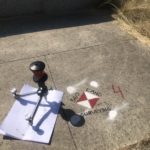
 October 15, 2019 6:11 pm
Published by bragdeal
October 15, 2019 6:11 pm
Published by bragdeal
We strive to keep up with technology, as well as provide the best service to our customers in the optimal (shortest) time. Having tested and tried various types f new gear, we've decided to acquire a high definition scanner - Leica Geosystem's RTC360.